Discerning riders are always keen to upgrade their existing dirt bike system with distinct accessories in order to amplify their riding experience. And this is why they are less likely to overlook a GPS to plan a trip of un-discovered trail with the least risk of terrain, track, weather conditions, and effective on-road features since it is enough to make you familiar with all the necessary aspects of a particular route before embarking on. But, you may not necessarily find a GPS device suitable for your dirt bike even after spending a considerable amount. This is because you didn’t focus on the specific factors while getting that. In this wake, in this article, we have articulated the buying guide after describing the best dirt bike GPS devices. Have a look at these picks before moving on to the buying guide.
Best Dirt Bike GPS Review
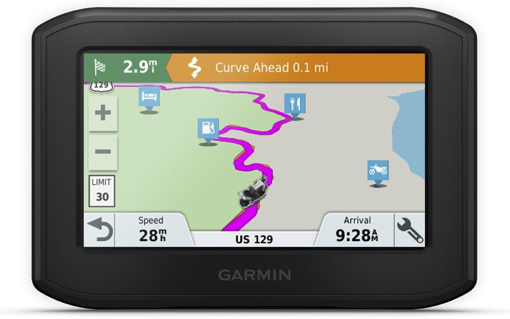
1. Garmin zumo 396 LMT-S, Motorcycle GPS with 4.3-inch Display
Key Features:
- Brand: Garmin
- Color: Black
- Screen size: 4.3” display
- Dimensions: 4.94” × 0.98” × 3.38”
- Weight: 1.76 lbs
- Input method: Touch screen
- Wireless connection: Available
Garmin Zumo 396 LMT-S motorcycle GPS is a phenomenal unit that has versatile features. With a 3.5″ screen, it gives clear readability whilst being weatherproof, fuel vapors resistant, and sun glare-resistant to avert view difficulty in the sunshine. Also, you can see the screen effortlessly in day time even with the beaming sun. Luckily, the screen does also has a glove-friendly touch. Obviously, no one would like to remove gloves in order to navigate through the screen, especially in a bumpy cold ride. In this scenario, this feature is worthwhile and undoubtedly a distinction of this product. But, exclusivity doesn’t end up here, there are two other features as well, making it stand out amongst the rest of the GPS units.
One of them is the Group ride with your partners which is quickly possible by following the GPX files sharing procedure with peeps, eventually enabling them to follow the same route. The next distinction lies in the ability to display information about the distance that can be traveled with current fuel status, low fuel warning (also show the gas stations around), mileage, performed maintenance, etc. Aside from providing all these services, it also limits the speed by “speed limit indicator” to give an alert on over speed. Besides exclusivities, see the other common functions below.
So this rugged product, being untypical, allows synchronization with a smartphone as well. You might be thinking it is common and generic, but wait, it is not that simple. Rather there is an array of functions to be performed by this connectivity. Astonishingly, you will be able to receive calls with a single touch on the screen while riding and having a phone in your pocket. Not only this, the hands-free connection will keep you at ease in listening to calls. Having said that, message notifications will also pop up on the screen including customizable notifications. Recalling, this all can be entertained by sync with a smartphone, Bluetooth-enabled helmet, or headset.
Regarding terrain, there are three settings related to curves, hills, and highways. All you need to do is simply drag a movable bar on a horizontal scale of every preference from low to high. This has been built in the view of adventurous dirt bike riding through narrow, curved, and hilly tracks. Following the terrain, you can also see the traffic and weather conditions on the road. However, for this, you need to connect this product with a smartphone link app that is free to use. In the traffic conditions; upcoming Sharp curves, school zones, speed changes, railroads, animal crossings, speed camera alert, state helmet law indicator, and a fatigue warning for taking breaks in long routes are included.
Concerning navigation tools, the maps of North America are preloaded along with TripAdvisor ratings for attractions such as hotels, restaurants, etc. For convenience, voice navigation has also been enabled to get on a certain path while following the map that is either used unchanged or often personalized by adding points to adjust the route. Interestingly, you can go home back following the same route you had a trip on by just using the feature of “TrackBack“.
Ending describing it, the Wi-Fi setup is also built in the device for updating maps and software, preventing connecting it with the computer.
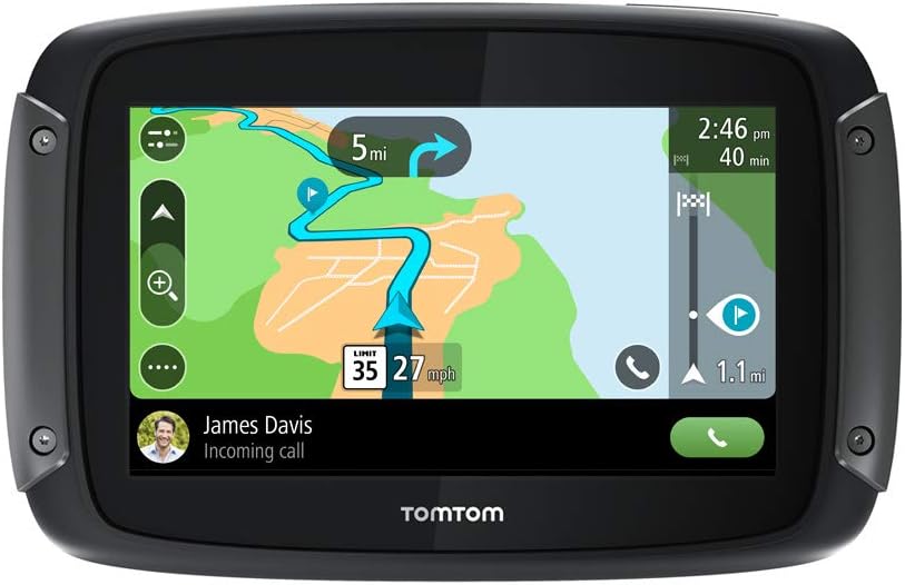
2. TomTom Rider 550 Motorcycle GPS Navigation Device
Key Features:
- Brand: Tom Tom
- Color: Black
- Screen size: 4.3”
- Dimensions: 5.4” × 1.2” × 3.5”
- Weight: 9.9 ounces
- Input method: Touch screen
- Wireless connection: Available
On the account of serving a lot of functions. TomTom Rider 550 motorcycle GPS is not a valueless choice. The screen size is appropriate for smooth readability with high brightness in sunlight too. Being distinct characteristics, the glove-friendly, as well as a weatherproof touch screen, are of great significance for discerning riders in the wake of unpredictable weather conditions and adventurous rides. Further, about the weatherproof build, this is ipx7 certified design, hence giving complete control efficiently.
Apart from the weatherproof build, one of the most highlighted qualities is the Wold map. This device comes with preloaded world maps, so you need not add any other map. You can enjoy street and topographical maps aside from the city tour.
Another uniqueness of this product is its quad-core processor that does not only enhance processing speed but also the GPS’ startup speed almost fivefold.
Besides special features, have a quick overview of other features below.
So to plan your trip, just search out the most challenging routes on either hilly or windy roads by adjusting the hilliness and windiness levels from low, mid, and high. Also, you can personalize it by adding breaks and stops on the route for having entertainment alongside the ride. This planning with MyDrive feature is sufficient to make you enjoy a roundtrip on breathe taking mountains.
To upgrade your planned journey experience, the map will also show the traffic conditions; delays, faster routes, and speed cameras. However, you have to connect the device with a smartphone via Bluetooth technology.
This Bluetooth connection will not just help you in this aspect, rather plenty of other facilities will also be there owing to being compatible with Google and Siri. They include the calls that can be received by the device as well as made by just using your voice to get a particular contact from the list, messages that are read aloud in the headset, and weather information by asking through the headset getting answered.
The common trouble of updating GPS with a computer connection is not found in this unique product since it has a built-in Wi-Fi for carrying out updating. All these characteristics altogether make it the best dirt bike GPS.
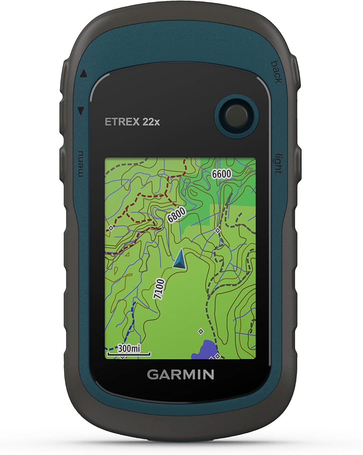
3. Garmin eTrex 22x, Rugged Handheld GPS Navigator
Key Features:
- Brand: Garmin
- Color: Black Navy
- Screen size: 2.2”
- Dimensions: 4” × 2.1” × 1.3”
- Weight: 5 ounces
- Input method: Buttons
- Wireless connection: N/A
Belonging to the eTrax series of Garmin, this GPS unit is quite small but in size only. With a 2.2” screen display, you can have a couple of useful features to have a quality ride.
The preloaded TopoActive maps enable knowing the natural features on route such as buildings, water bodies, and POI (points of interest) i.e. hotels, institutions, car parks, accommodations, etc. As an exclusive feature, the tracking with GPS and GLONASS satellite system make positioning fast and competent.
If you are an enthusiast rider, you might have had troubles regarding geocaching files that are not supported by every GPS unit. But, in this unit, we have the ease of downloading geocaches following location, terrain, hints, difficulty, etc. This will considerably reduce the effort of entering coordinates.
Regarding internal storage, the device comes with an internal 8GB memory. A drawback of this unit is that it needs a computer to update its software because a wireless connection is not supported.
4. Trail Tech Voyager Pro 922-125 GPS
Key Features:
- Brand: Trail Tech
- Color: Black
- Screen size: 4” display
- Dimensions: 6” × 4” × 8”
- Weight: 1.35 lbs
- Input method: Touch screen
- Wireless connection Available
Following the GPS devices, this unit has many nifty features. The colored screen is sealed, resistant to dust, water, and glare. You can conveniently view the screen from any angle since it is bright and resistant to glare.
The specialty of this product is the “buddy tracking” feature that will enable you to see the location of your friends (up to 20) live on the screen riding with you on the same route.
Besides it, navigation covers the topographic maps of North America. You can add your maps as well. Briefly, the topography maps will show the road features as well.
The product is unique in the way that it displays temperature, distance, speed, elevation, voltage, and RMP. The Bluetooth connection is also supported which enables for intercome, messaging, and calls. Fortunately, you can add two headsets and two phones at a time.
5. Garmin eTrex 10 Worldwide Handheld GPS Navigator

Key Features:
- Brand: Garmin
- Color: Yellow Black
- Screen size: 2.2”
- Dimensions: 2.13” × 1.3” × 4.06”
- Weight: 5 ounces
- Input method: Buttons
- Wireless connection: N/A
Although Garmin eTrax 10 GPS device is a handy unit, the mounting over the dirt bike will truly serve you efficiently despite its small size. For being handy, its screen size is very small compared to other under discussion devices but easily readable day and night with its monochrome display. Like the TomTom GPS unit, this is also waterproof and IPX 7 certified.
Simply mount it on your bike with handlebars and enjoy your trips with added World base map displaying topographic maps including elevation profiles and counter lines. Also, you can share your planned trip with family or friends.
The standing out feature of this unit is the compatibility with GPS as well as GLONASS satellites. enabling you to get faster service even in deep canyons. This is also because the sensitive unit is able to predict HotFix satellite prediction to precisely locate your position and maintain GPS accordingly. You can also have a plethora of satellite images after getting paired with BirdsEye Satellite (subscription needed).
Like eTrax 22x, this unit also supports geocaching files. A drawback of this device is that a wireless connection such as Bluetooth is not supported so you will not be able to enjoy functions like attending calls and having chats while riding.
Another worth-mentioning thing is its battery life that can work for 25-hrs, undoubtedly the best feature.
Conclusion
All of the above recommendations are top-notches on the account of practicality, durability, and affordability. However based on the radical features, compatibility, and exclusive functions, “Garmin Zumo 396 LMT-S motorcycle GPS” stands out among all. It has many useful settings besides GPS making it act like a speedometer. Also, it is economical and affordable. If you are more concerned with the budget, we recommend “Garmin eTrex 22x Handheld GPS Navigator” as the best cheap dirt bike GPS. Hear in we must say, do not underestimate its functionality seeing its cost only.
Explore More 1. Best Dirt Bike Speedometer | Reviewed